Day 01: Arrive at Paro
You will land at Paro international Airport, after having experienced one of the most thrilling journeys of your lifetime – the flight to Paro, during which you experience a breath taking view of Mount Everest, Kanchenjunga and other famous Himalayan peaks, including the sacred Jomolhari and Mount Jichu Drake. The landing at Paro, considered one of the most challenging is an enthralling experience.
At the airport, you will be received by our company’s representatives. You will visit some of the standing treasures of Bhutan that Paro houses, such as the National Museum of Bhutan and the grand Paro Rimpong Dzong (Fortress on a Heap of Jewels). After lunch at a local hotel, you will visit Kyichu temple, one of the oldest temples in Bhutan built by King Songtsen Gyempo of Tibet in 659AD. Legend has it that the Buddhist King built 108 temples within a day, Kyichu being one.
Day 02: Paro – Excursion Taktsang
After an early breakfast, we drive up to Ramthangka, (base camp) of Taktsang and then hike to one of Bhutan’s most sacred and religious heritage, Taktshang Monastery or the “Tiger’s Lair.” Perched some 1000 meters on a hill overlooking a valley, it is believed that the great Indian Saint and Buddhist Master, Guru Padma Sambhava flew on a tigress in a wrathful form to this place in 746 AD, to subdue evil forces who were obstructing the spread of Buddhism. The trek, which will take about five hours (up and down) is an unforgettable one and promises every visitor an enthralling experience.
In the evening, you will visit ruins of the Drugyel Dzong, ”Castle of the Victorious Drukpa” located 16 Km. from Paro town. The Dzong was built to celebrate the victory of the Bhutanese forces over the invading Tibetan troops. On a clear day, one can view Mount Jomolhari (“Mountain of the Goddess”) standing at an altitude of 7,329m/24,029ft.
Overnight at hotel.
Day 03: Paro – Shana: (Distance 17km, four to five hours, 360m ascent, 80m descent, camp altitude 2,850m)
The actual trek now begins.
We will drive up to Drukgyel Dzong till the motor-able road ends. The trek to Shana begins which is about 5 to 6 hours, gradually ascending following the Paro River through agricultural fields and villages. The campsite is opposite the army check post in the meadows, near the river at an altitude of 2,580m.
Day 04 : Shana – Soi Thangthangkha: (Distance 22km, seven to eight hours, 770m ascent, 10m descent, camp altitude 3,610m)
The trail is a gradual ascend following Paro River through conifers and Rhododendron trees. The Camp is in the meadow with stone shelter built for trekkers surrounded by conifer and birch forests and on clear days one can have a magnificent view of Mt. Jomolhari.
Day 05: Thangthangka – Jangothang: (Distance 19km, five to six hours, 480m ascent, camp altitude 4,080m)
The trail crosses the army post and the valley begins to widen and you will reach the winter houses of yak herders where hot lunch will be served in one of the houses. We will camp beneath a ruined house (fortress) at the base of Mt. Jhomolhari, Jangothang.
Day 06: Jangothang Halt.
The day in Jangothang provides plenty of possibilities for day hikes with great views of lakes and snow capped mountains such as Jhomolhari and Jichu Drake. There are good chances to spot some blue sheep.
Day 07: Jangothang- Lingzhi: (Distance 18km, six to seven hours, 840m ascent, 870m descent, camp altitude 4,010m)
After breakfast we start ascending towards Nyelila. You will see Mt. Jhomolhari, Mt. Jichu Drake and Tsherim Gang till Nyelila (Pass) at which point you will be seen off by the former two mountains. There after you will be seeing only Tsherim Gang. From Nyelila pass the trail leads you all the way down to the camp.
Day 08: Lingzhi – Chebisa: (Distance 10km, five to six hours, 280m ascent, 410m descent, camp altitude 3,880m)
The walk is through Gongyuel village and if you are lucky you might see the Raven bird and herds of blue sheep. You then reach a small village called Chebisa, winter house of yak herders.
Day 09: Chabisa – Shomuthang: (Distance 17km, six to seven hours, 890m ascent, 540m descent, camp altitude 4,410m)
You will ascend the steep hill side till Gobula pass, (14,268 ft.) From there the walk is a very gradual descend till you get to the tree line, which is the campsite by a river.
Day 10: Shomuthang – Robluta: (Distance 18km, six to seven hours, 700m ascent, 760m descent, camp altitude 4,160m)
The walk starts a little early and we head towards Jhari La pass (4760 m.) From here you drop to Tsharijathang, the valleys where herds of Takin are usually seen grazing in the meadows.
Halt night in camp.
Day 11: Robluta – Lemithang: (Distance 19km, six to seven hours, 850m ascent, 870m descent, camp altitude 4,140m)
You will be passing over the highest point on this trek, Shingela Pass at 16,072ft/4,870 m. The walk is tough till the top, and from there you start descending towards Lemithang. You trek through the valley till Lemithang, which is under Laya District. Here you will encounter the people of Laya.
The camp at Lemithang is beneath Gang Chen Ta, “Great Tiger Mountain.” If time permits it is worthwhile to spend a day exploring the area. Night will halt in camp.
Day 12: Lemithang – Laya: (Distance 10km, four to five hours, 60m ascent, 340m descent, camp altitude 3,840m)
The walk for the day is all the way downhill along a winding river. As you walk down, the path splits in two, one going down in the direction of the river to the campsite which is also used by the army, and the other maintains almost the same height and leads you to the west side of Laya village. You can camp on this flat bench sort profile above the East end of Laya village.
Day 13: Laya – Halt
Rest and explore the Laya village.
Day 14: Laya–Rhoduphu: (Distance 19km, six to eight hours, 1,030m ascent, 750m descent, camp altitude 4,160m)
The trek leads gradually downhill to the Lunana trail junction, and then makes a gradual climb to the camp through a forest of conifers, maple and rhododendron. The Trail improves and becomes wider as we climb out of the river valley. Halt camp at Roduphu near a small stream.
Day 15. Rhoduphu – Narethang: (Distance 17km, five to six hours, 740m ascent, camp altitude 4,900m)
It is a long hike crossing the Tsimo La pass at 4950m(16,200) and descending to NarethangThe campsite at Narethang is towered by the peak of GanglaKarchung (6,395m).
Day 16: Narethang-Tarina: (Distance 18km, five to six hours, 270m ascent, 1,200m descent, camp altitude 3,970m)
From the camp you will climb for about an hour to Ganglakarchung La (5,120m) and then to Karchung La pass at 5240m(17,187 ft) and down glacial lakes, which are sources of the Tang Chhu in Bumthang. Above the lakes are the mighty peaks of Jejekangphu Gang (7300m) and Tsenda Kang (7100m). Halt camp in Tarina.
Day 17: Tarina-Woche: (Distance 17km, six to seven hours, 270m ascent, 330m descent, camp altitude 3,910m)
The walk leads down through conifer forests following the upper ridges of the Pho Chhu, passing some impressive waterfalls. The trail then climbs over a ridge and drops to Woche, a settlement of a few houses, the first village in the Lunana region.
Day 18: Woche-Lhedi: (Distance 17km, six to seven hours, 980m ascent, 1,190m descent, camp altitude 3,700m)
It’s a steady climb from Woche to Keche La (pass at 4580m (15,100 ft), and then downhill to Thega village. The hike continues to Lhadi village where we camp.
Day 19: Lhedi-Thanza: (Distance 17km, seven to eight hours, 450m ascent, camp altitude 4,150m)
The trail climbs gradually following the main source of Pho Chhu to Chozo village. Above Chozo the valley opens as we approach Thanza village near the foot of 7100m ZogophuGamp, which is known as the Table Mountain.
Camp site is at Thanza.
Day 20: Thanza-Halt
You have a fantastic opportunity to interact with the hospitable local villagers and explore the beautiful surrounding till the farthest point in Lunana valley. As Thanza is a transfer point for horses and yaks, it is important to spend a day here for our staff to ensure all the necessary yaks are rounded up by the local herders.
Day 21: Thanza- Danji: (Distance 8km, three to four hours, 80m ascent, camp altitude 4,230m)
Today is a relatively short trek but the track is steep. We have to climb a campsite called Danji, and ascend to Jaze la pass. The camp offers spectacular views of snow-capped peaks.
Day 22: Danji-Tsochena: (Distance 12km, five to six hours, 980m ascent, 240m descent, camp altitude 4,970m)
It begins with an initial uphill ascend over three summits to Jaze La pass at 5050 m (16,570 ft). From the pass it is a short downhill trek to the campsite at Tsochena lake.
Day 23: Tsochena – Jichu Dramo: (Distance 14km, four to five hours, 230m ascent, 150m descent, camp altitude 5,050m)
The trail has a series of gradual up and down between the snow-capped peaks and across Loju la pass at 4940 m (16,300 ft) before descending to the camp at Jichu Dramo.
Day 24: Jichu Dramo-Chukarpo: (Distance 18km, five to six hours, 320m ascent, 730m descent, camp altitude 4,600m)
We start with an arduous climb to Rinchen Zoe La pass at 5290m (17,350 ft), the highest on the trek. It is then all downhill to Chukarpo, which is just above the tree line.
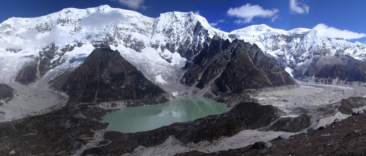
Day 25: Chukarpo-Thampe Tso: (Distance 18km, five to six hours, 400m ascent, 700m descent, camp altitude 4,300m)
This is a long downhill walk along the river, followed by a climb up to the ThampeTso, a beautiful clear turquoise lake, with the campsite next to it.
Day 26: Thampe Tsho-Maurothang: (Distance 14km, five hours, 330m ascent, 1020m descent, camp altitude 3,610m)
This is also a short walk to the base of Thampe La and a steep climb to the pass at 4580m (15,100 ft). The trek is then all downhill through rhododendron bushes to the yak pasture of Maurothang where we will camp.
Day 27: Maurothang-Sephu: (Distance 18km, five to six hours, 990m descent)
On the last day of this extraordinary trek your porters will have to change from yaks to horses as the yaks will not be willing to go further down. The path follows the Nikka Chhu to reach a large grassy area overlooking the road and the village of Sephu. You finally reach the road at the Nikka Chhubridge, from where we will drive to Punakha.
Night halt in Punakha.
Day 28: Punakha-Paro
We will visit Punakha Dzong, which was Bhutan’s capital until 1955 and still is home of the Chief Abbot during the winter months. Punakha Dzong (Fortress), built in 1637 by Shabdrung Ngawang Namgyal, stands like a giant ship on an ocean from afar. Build at the confluence of two rivers, Pho Chhu(male river) and Mo Chhu (female river), the Dzong was destroyed four times by fire and an earthquake in 1897. However, it has now been restored to its original splendour.
En-route to Thimphu we will visit Chhimi Lhakhang, which was built in the 15th Century, dedicated to Lama Drukpa Kinley also known as the “divine mad man”. It is a pilgrim site especially for childless couples, where the Phallus is worshipped. It is believed that blessings from the phallus help a woman to conceive. We continue driving to Paro and halt at a hotel.
Day 29: Departure from Paro
After breakfast, you will be driven to Paro international airport for your onward flight. Our representative will see you off.